|
| |
History
Kilimanjaro - one of the world's seven summits and the highest point in
Africa (19,340') - is instantly recognized by people all over the world.
This almost perfectly shaped, snowcapped volcano rises sheer from the
plains, and is one of Africa's most magnificent sights.
For many years, Kilimanjaro's white peak was a mystery to the local people
to whom snow and glaciers were unknown. The first recorded sighting of the
mountain dates back some seven hundred years when a Chinese fisherman wrote
of a white peak on the African coastline. The outside world knew nothing
about the mountain before 1848 when the Swiss missionary Johannes Rebmann
became the first European to lay eyes on Kilimanjaro. He reported his
discovery of a snow-peaked mountain in East Africa to the Royal Geographical
Society in London, but nobody believed him. In 1897, the German explorer
Hans Meyer and his Chagga guide, John Lauwo, became the first recorded
people to successfully summit Kilimanjaro. One hundred years later a
celebration was held to mark the centenary of this event - the guest of
honor was the original local guide. He was 118 years old!
After Tanzania achieved its independence in 1961, Kilimanjaro was
transformed into a National Park. Covering some 7,500 square kilometers, it
is now listed as a World Heritage Site. Currently, about 24,000 people a
year attempt to climb Kilimanjaro. Official records state that about 15%
make it to the summit |
|

 Geology Geology
Kilimanjaro (Kilima Njaro or "shining mountain" in Swahili) consists of
three major volcanic centers - Kibo (19,340') in the center, Mawenzi
(16,893') in the east, and Shira (13,140') in the west. Uhuru Peak at
the crater rim is the official summit point. Currently, only Kibo
retains glaciers - and unfortunately, the glaciers are melting so
rapidly that some researchers estimate they will all be gone by the year
of 2020. According to U.S. researchers, the glaciers measured 4.8 square
miles in 1912 and had shrunk to 1 square mile in 2000. Further research
is needed to determine to what extent global warming and/or natural
climate variability are responsible for the demise of Kilimanjaro's
glaciers.
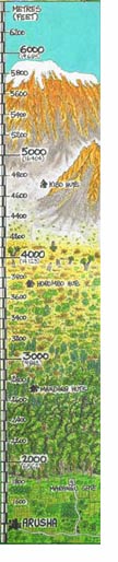
A climb of Kilimanjaro will take you through an amazing variety of
landscapes - parallel to traveling from the equator to the Arctic! This
makes Kilimanjaro an incredibly special trip:
Cultivated farmland. You'll start your trek through pastures,
plantations, and grassland. Much of the food consumed by climbers and
porters on Kilimanjaro originates from the farms at the foot of
Kilimanjaro. This area gets heavy rainfall and is in theory part of the
next zone - forest. Before farming this area was covered with shrubbery
and dense forest. (Up to about 6,000'.)
Forest. Very lush vegetation drenched in heavy rainfall (almost
80 inches per) with a number of endemic plants such as Impatiens
Kilimanjari and Senecio Johnstoni. (About 6,000-9,800'.)
Heather. An often misty foggy zone near the forest with a variety
of heather-like shrubs. (About 9,600-11,000'.)
Moorland. As you climb into this eco zone, the weather will
likely be cool, clear, and intensely sunny. (So, don't forget your
sunscreen!) You will still enjoy clusters of plants endemic to
Kilimanjaro. (About 11,000-13,000'.)
Alpine desert. In this zone, chances are you'll wear almost
everything you have brought within 24 hours! Temperatures usually
fluctuate wildly from days of 95 degree heat to nights below freezing!
This is a barren and lunar-like landscape - not at all favorable for
plants. (About 13,000-16,500'.)
Summit. Welcome to arctic conditions! Freezing cold at night and
burning sun during the day. The air pressure falls and here there is
only one-half the amount of oxygen in the air as at sea level, so get
your summit picture and get back down! (About 16,500-19,340'.)
|
|
|